Background
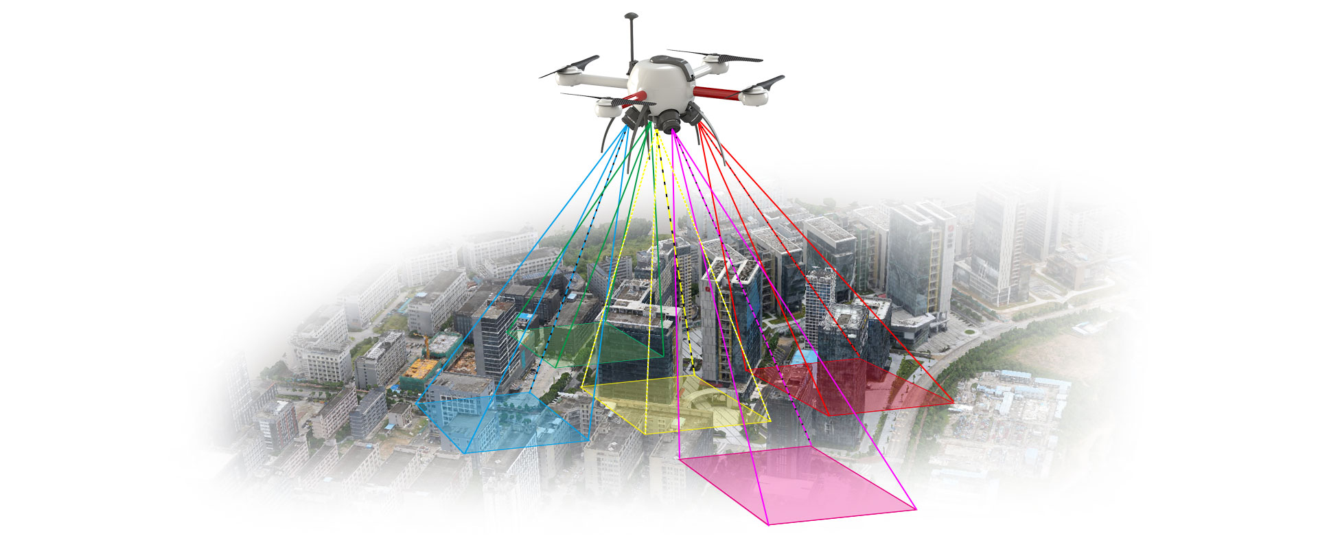
UAV photogrammetry refers to acquiring HD stereoscopic images from
a vertical angle or four angles of inclination (45°) by
ultra-low-altitude photogrammetry, and gathering information from
multiple angles. To match up with the ground control point or POS
information on images, every point on the image will show a
three-dimensional coordinate. With the gathered image data with
cm-level measurement accuracy, a 3D geographic information model
will be automatically created for fast acquisition for geographic
information and direct measurement of height buildings. Our
oblique photogrammetry system is high efficient, low-cost, easy to
use, and will gain precise data and available profile information;
and it further facilitates indoor and outdoor surveying and
mapping.
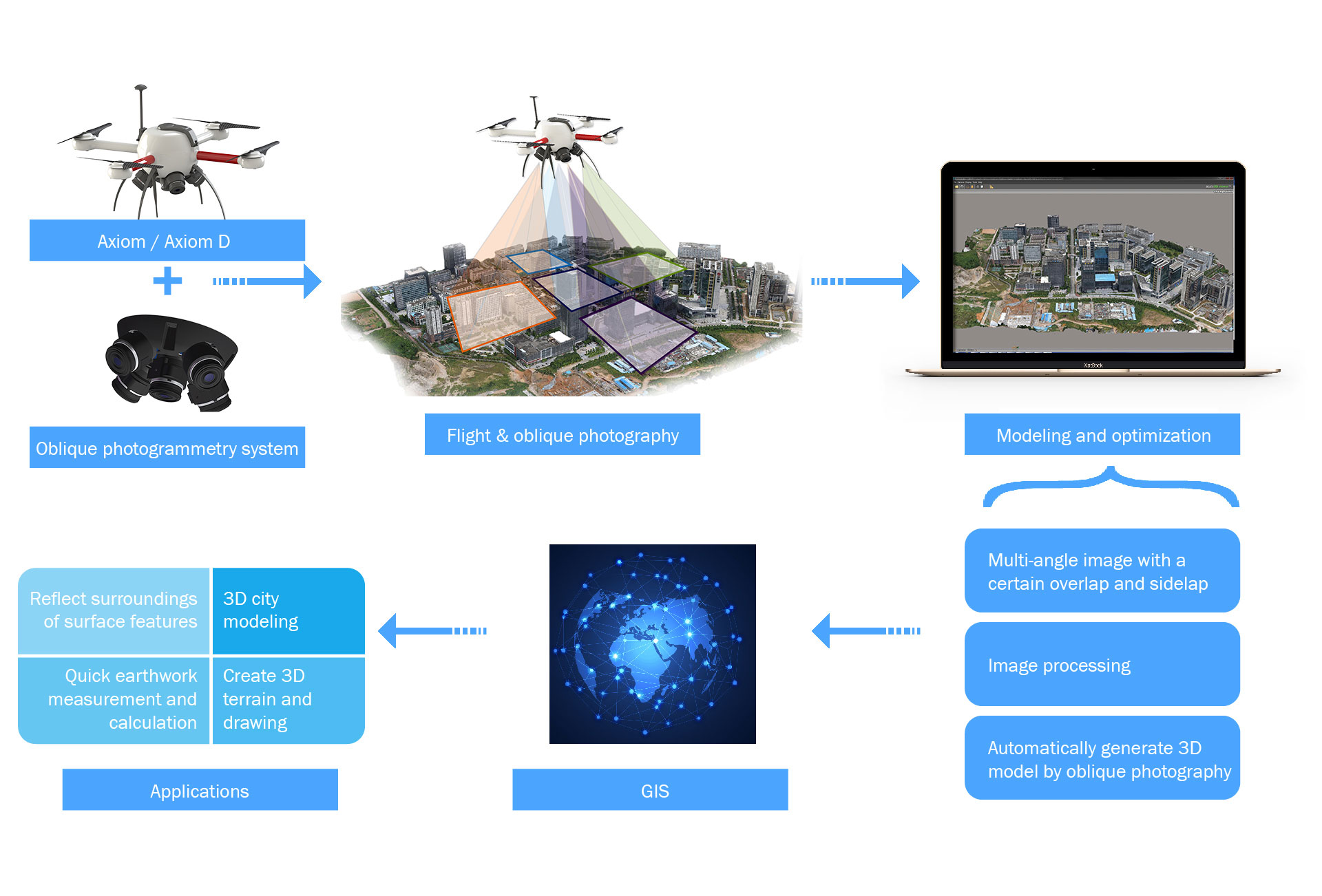
What Our UAVs Can Do
| 3D city modeling
At present, traditional 2D data fails to satisfy the routine
work of every sector in cities, and visualization of 3D data
has become an important link of urban infrastructure
construction and planning and an important way to present a
digital city. Digital city is a virtual space integrating
information of cities and is stored on the Internet of
computer where users can access to geographic information of
cities; and it is part and parcel of digital earth.
Joyton UAV oblique photogrammetry system will use professional
software to create point cloud and then build a model based on
the images acquired. Compared with traditional mobile survey,
Joyton oblique photogrammetry UAV system is more efficient and
precise as it will capture oblique and nadir images for quick
3D modeling.
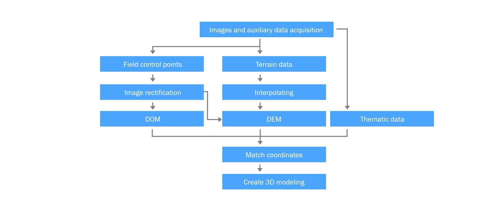
Working principle:
| 3D terrain and drawings creation
With Joyton UAV oblique photogrammetry system, we are able to
directly import terrain and landform photographs and
geographic information acquired into professional processing
software and instantly work out a 3D model by precise
algorithms of the software. Finally, the 3D model can be
exported in any form, and drawings will be made by putting the
3D model into drawing software.
| Quick earthwork measurement and calculation
Joyton UAV oblique photogrammetry system will import the
earthwork image data acquired into professional software for
automatic calculation, and then make quick and precise
measurement of the height, length, area, angle, and gradient
of the earthwork.
Earthwork
calculation principle:
1. Joyton
UAV oblique photogrammetry system acquires elaborate image
data.
2. Import
data into professional processing software, one-click generate
point cloud and automatically stimulate space frame.
3. Automatically
generate 3D point cloud model, render real texture and export
all-purpose data for 3D point cloud model.
4. Compute
the volume of point cloud model data to get the volume of
earthwork.
| Reflect surroundings of surface features
Joyton UAV oblique photogrammetry system is equipped with five
or two HD cameras, and compared with orthophoto maps, the
images gathered enable users to clearly observe surface
features from different angles and provide more real actual
information on surface features, greatly making up the
limitation of traditional orthophotography.
With regard to surveying and mapping of ancient buildings and
subsequent renovation, oblique aerial photography
characterized by large-scale mapping, batch extraction,
processing and texture rendering can effectively reflect the
conditions of the ancient buildings and the surroundings,
effectively reducing 3D modeling cost for ancient buildings
and time for renovation.
What Our UAVs Will Bring You
Joyton UAV oblique photogrammetry system is verified good and
widely applied in the sectors like police, emergency response,
surveying and mapping, tourism, environment protection and
agriculture. It is highly praised by different users, and wins
remarkable economic benefits, playing a demonstration role and
worthy of promoting and popularizing. It helps to reduce a great
deal of manual field survey, accelerates the progress of projects
and unfolds before our eyes the actual conditions of buildings and
targets.
Copyright © 2016-2024 Joyton | Shenzhen Joyton Innovation Technology Co., Ltd.