Background
Geographic information acquisition is widely applied to the
economic development and national defense construction and is of
indispensable importance.
It is a must to gather detailed geographic information and measure
the terrain and topography in the course of planning, management
and construction concerning urban and rural construction planning,
use of state-owned land resources, forest right definition,
environment protection, geological exploration, mining, hydraulic
engineering, transportation and so forth.
Traditionally, geographic information is acquired by manual field
measurement or by a big plane with cameras, while which is
low-efficient, requires long period length, high cost, and lacks
of detailed information about complicated roads; and the results
acquired might be simple, incomplete and inaccurate.
What Our UAVs Can Do
Joyton Radius (fixed-wing) with an optical stabilized lens
(18.2mp) is designed to facilitate traditional manual field
acquisition of geographic information. UAV aerial information
acquisition system is now an important approach to acquiring
spatial data, characterized by such advantages as fast, efficient,
flexible, precise, accurate, low-cost, widely applicable and able
to make inspection in confined areas, small areas and areas where
it is hard for normal flight. UAV aerial photogrammetry system can
collect high-resolution aerial photographs to create
high-precision orthophoto maps and DOM.
What Our UAVs Will Bring You
Joyton Radius system employs state-of-the-art science and
technologies, remote sensing, telemetering, remote control and so
on, which capacitates it to gain accurate topographic maps by
aerial remote sensing photography on all kinds of state-owned land
for construction and agriculture and undeveloped land, fully
improving the level and efficiency of investigation and monitoring
of state-owned land resources and reducing man-made interference.
It is also helpful for avoiding being given false or concealed
materials of state-owned land resources, thus to acquire accurate
and precise terrain and cadastral information.

Practical Applications
| Land right definition
Traditionally, regarding land right definition, people usually use
tapeline or total station to make measurement on the land, which
will not be beneficial to get sophisticated and accurate data nor
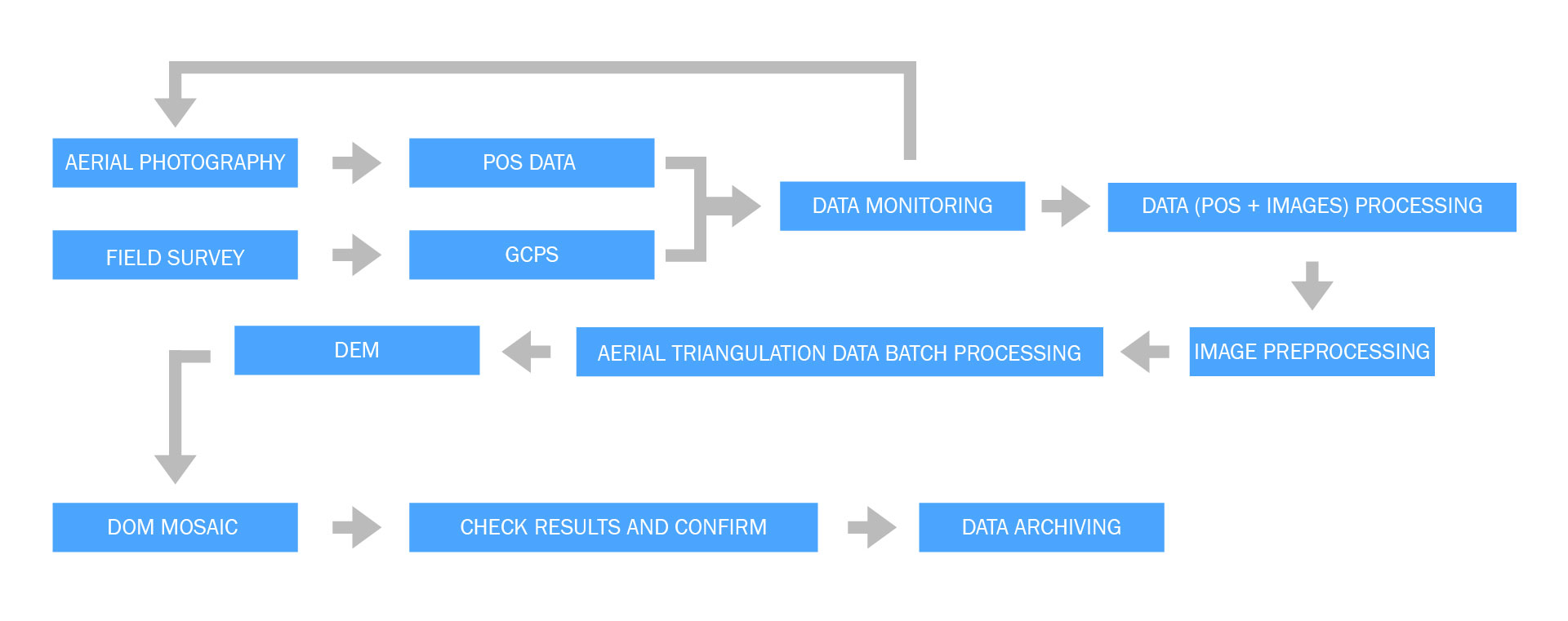
avoid damaging cropland and crops. Joyton Radius with an optical
stabilized sensor system (18.2mp), with the aid of the ground
station software system, is able to directly plan flight path
within the target range, so that it can face and film the land at
a low altitude to acquire images, based on which, point cloud data
will be worked out after those images are processed by
professional software, and then texture will be generated. Hence,
we will get orthophoto map model of land with different
high-precision scales such as 1:500, 1:1000 and 1:2000, which
provides accurate geographic information for confirming land
rights and enhances the accuracy and efficiency of land right
definition.
| Urban planning
As Joyton Radius can rapidly gain ground and surface data, we can
fast and efficiently gather geographic information and generate a
full-fledged GIS for decision-maker to make long-term plan for
rational use of land.
Copyright © 2016-2024 Joyton | Shenzhen Joyton Innovation Technology Co., Ltd.